Main Line of Public Works
Essay
During the 1820s, seeking to compete with New York and Baltimore in tapping western markets, business and political leaders in Philadelphia pushed for a state-funded canal to link Philadelphia with Pittsburgh. The result, an innovative yet peculiar patchwork of canals and railways known as the Main Line of Public Works, succeeded in moving freight and passengers across the mountainous middle of Pennsylvania. The 395-mile system reduced travel time and spurred growth of towns and market activity along the line, but it proved costly to operate and plunged the state into debt. Within three decades, more powerful locomotives rendered the Main Line of Public Works obsolete.
The impetus for the Pennsylvania canal scheme came largely from the looming threat of New York’s state-funded Erie Canal, which began construction in 1817. When completed in 1825, the canal linked the Hudson River to the Great Lakes, thus extending New York City’s orbit of trade to all the western interior and vastly increasing its competitive edge over Philadelphia. Additional threats to Philadelphia’s economic standing lay to the south, where Baltimore benefited from the movement of agricultural products down the Susquehanna River from Pennsylvania’s interior. The National Road, a federal east-west road project begun in 1811, also siphoned travel and trade from the southwestern corner of Pennsylvania into Maryland, where it connected with the Baltimore Turnpike.
Facing the loss of economic standing and recognizing the potential for trade as Americans moved west, Philadelphia business and political leaders campaigned for an improved transportation system to span across Pennsylvania. Since the colonial era, Philadelphia had looked west as far as Lancaster—about sixty-five miles away—for trade and travel enabled by the Philadelphia-Lancaster Road (a paved toll road after 1795). They also looked northwest to Reading, established in 1748 along the Schuylkill River. A canal between Reading and the Susquehanna Rivers, discussed since the 1790s, did not come to fruition until 1821. Meanwhile, developments in the early nineteenth century added to Philadelphians’ imagination of an economic region reaching farther into the interior of Pennsylvania and beyond: the state capital moved from Philadelphia to Lancaster in 1799 and then to Harrisburg in 1812; Pittsburgh grew from the site of a fort into a city; and new western states came into the union (Ohio in 1803, Indiana in 1816, and Illinois in 1818). Whetting appetites for new fortunes, opportunities in the West were growing as steamboats began to ply the Ohio and Mississippi Rivers, reaching the expanding territory of cotton agriculture in the deep South. What could Philadelphians do to claim a share of the riches to come from the interior? How could they compete with New York and Baltimore, which seemed to be pulling ahead in the race to reach the West?
The Canal Campaign
Matthew Carey (1760-1839), newspaper editor and political economist, launched a vigorous campaign for a state-funded canal between Philadelphia and Pittsburgh. Together with such prominent citizens as Congressman John Sergeant (1779-1852) and Nicholas Biddle (1786-1844), then president of the Second Bank of the United States, Carey formed the Pennsylvania Society for Promotion of Internal Improvements. With dues collected from fifty-five members, the society dispatched the architect and engineer William Strickland (1788-1854) to England to study the latest in transportation technology. Although Strickland returned with data that included the newest technology, railroads, Carey pushed aggressively for the more time-tested alternative of canals. Petitions, pamphlets, newspaper editorials, and mass meetings added momentum, despite opposition from southern Pennsylvania counties that traded with Baltimore and northeastern counties with economic ties to New York. In 1825, an Internal Improvement Convention in Harrisburg endorsed Carey’s preference for a canal, and the next year the Pennsylvania legislature authorized construction of a state-funded Pennsylvania Canal between Philadelphia and Pittsburgh. Adding a note of patriotic nationalism, construction began on the nation’s fiftieth birthday, July 4, 1826.
Canal fever faced unavoidable hurdles of geography. Across the breadth of Pennsylvania, the state’s major rivers offered good settings for canals, but not continuously and not in a straight line between Philadelphia and Pittsburgh. And how could a canal possibly climb over the Allegheny Mountains? Such barriers did not stop the Main Line of Public Works. After nine years of construction, the system offered a journey that started in Philadelphia by rail—but the new Philadelphia and Columbia Railroad first moved by horsepower from a terminal near Broad and Vine Streets (then the northern city limits) across the Schuylkill via a newly built Columbia Viaduct Bridge. Then, a stationary steam engine pulled the cars by cable up an inclined plane to the top of Belmont Plateau in the area later incorporated into Fairmount Park. Thus positioned, cars could be joined to a steam locomotive to ride the rails west via Lancaster and down another inclined plane to Columbia on the Susquehanna River.
From Columbia, the journey continued northwest by canal alongside the Susquehanna and Juniata Rivers until the densely forested Allegheny Mountains blocked the way. At this juncture, at the town of Hollidaysburg, the trip required changing from water travel to another system of inclined planes, this one far more extensive than the beginning incline in Philadelphia. The Allegheny Portage Railroad involved hauling cars along a thirty-six-mile sequence of ten inclines and through a tunnel—the nation’s first for a railroad—to conquer a 1,400-foot change in elevation. After the trip over the mountains, the Main Line continued by canal from Johnstown to its ultimate destination in Pittsburgh. By the 1840s, the burdens of transferring people and cargo between canals and railways diminished with the introduction of canal boats that could be separated into sections to ride on rail cars when necessary and then reattached to return to the water.
Human Toll of the Route

Built at a cost of more than $12 million, the Main Line also extracted human costs as laborers, many of them Irish immigrants, constructed the system’s railroads, canals, 174 locks, forty-nine aqueducts, and three tunnels. At a spot in Chester County known as Duffy’s Cut, fifty-seven Irish laborers for a contractor building the Philadelphia and Columbia Railroad died during a cholera outbreak during the summer of 1832. Later archaeological investigation revealed blunt-force trauma to some workers and one with a bullet wound.
The Main Line of Public Works succeeded to the extent that it cut travel time between Philadelphia and Pittsburgh from twenty-three days to about four, and it moved both freight and people between Philadelphia and the West. However, it did not restore Philadelphia to its earlier primacy in American trade because it could not compete successfully with the lower costs and easier transit available on the straight-line Erie Canal. Nevertheless, the Main Line brought products such as wheat, flour, whiskey, and lumber into the port of Philadelphia, and it carried manufactured goods from the city to the interior. Along the line, Columbia, Hollidaysburg, and Johnstown became bustling towns. The Main Line’s passengers included the English novelist Charles Dickens (1812-70), the “Swedish Nightingale” singer Jenny Lind (1820-87), and Jarena Lee (1783-64), the African American circuit preacher. The system also played a role in the Underground Railroad, as abolitionists including the lumber partners William Whipper (1804-76) and Stephen Smith (1795-1873) used their own boats and rail cars to move freedom seekers surreptitiously along the line.
By the 1850s, however, more powerful locomotives made railroads a more feasible option through mountainous terrain as well as a faster alternative to canals. In 1857 the state, deeply in debt from construction of the Main Line and other canals, sold the line to the Pennsylvania Railroad Company. Engineering of the Horseshoe Curve in central Pennsylvania ended the need for the Portage Railroad, which faded, abandoned, into the landscape. The “Main Line” ceased to exist in its original form, but the name nevertheless survived for the subsequent line of the Pennsylvania Railroad and especially in reference to the elite suburbs that developed along the line west of Philadelphia. Remnants of the system through central Pennsylvania became recreational trails and parks, and tourists could visit the Allegheny Portage Railroad National Historic Site managed by the National Park Service.
Although short-lived, the Main Line of Public Works helped to link the eastern seaboard to the expanding interior of the United States. At a time when national politicians debated whether the federal government should play a role in “internal improvements,” the Main Line tapped state funds for the system sought by boosters of Philadelphia. In the end, though, New York’s Erie Canal proved to be more effective—even some merchants in Philadelphia shipped goods to the West via New York rather than bear the cost of multiple transfers of the Main Line.
Charlene Mires is Professor of History at Rutgers-Camden and Editor-in-Chief of The Encyclopedia of Greater Philadelphia. (Author information current at time of publication.)
Copyright 2020, Rutgers University
Gallery
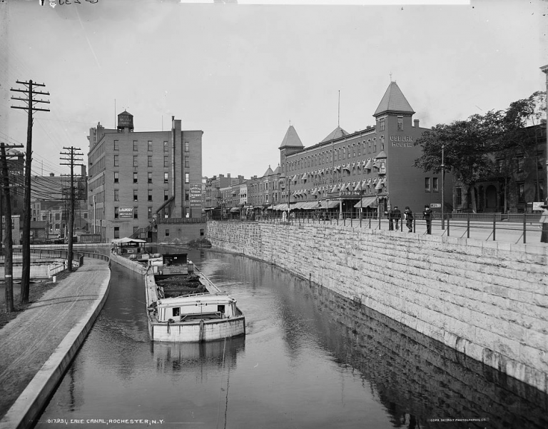
Erie Canal at Rochester, New York ca. 1900
The Erie Canal linked the Hudson River and the Great Lakes, dramatically decreasing shipping time and costs between the midwestern United States and New York City. The immensely successful project, opened in 1825, increased New York’s economic advantage over Philadelphia. It allowed the city to enter markets in the new states of Ohio, Illinois, and Indiana and to connect with the Mississippi where cotton trade from the South proved especially lucrative. This competition, along with the growth of Baltimore to the south, prompted Pennsylvania’s business and political leaders to campaign for an improved transportation network between Philadelphia in the east and Pittsburgh in the west, connecting Pennsylvania to these markets in the midwestern territories.
While the Main Line Works faltered after only two decades of operation, the Erie Canal remained in operation long into the twentieth century. The canal was expanded several times, including a realignment completed in 1918 at a cost of $96.7 million. Commercial riverboats continue to utilize the canal, and it is also used for irrigation, hydroelectric power, and recreation. It was designated a National Historic Landmark in 2016. Some segments of the original alignment have also been restored and are designated a New York State Historic Park.

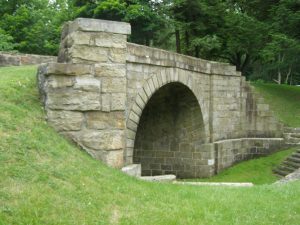
Skew Bridge, Allegheny Portage Railroad
The Allegheny Portage Railroad used a complex system of inclined planes, tunnels, and a skew arch bridge to connect two segments of the Pennsylvania Canal across the Allegheny Mountains. The thirty-six mile system spanned the rough terrain between Hollidaysburg in the east and Johnstown in the west. At the time of construction, steam locomotives were not powerful enough to pull the heavy rail cars loaded with river boats and barges up the steep inclines of the mountain range. Instead, the cars were pulled by stationary steam winches up the inclines and by mules at grade. The 900-foot Staple Bend Tunnel in Mineral Point was the first use of a railway tunnel in the United States. The skew arch bridge in Cresson, shown in this modern photograph, required precise stonework to span the uneven terrain.
While seen as an engineering marvel when it opened, advances in railway technology rendered this system obsolete. The construction of the Horseshoe Curve, itself a feat of engineering, circumvented most of the Portage Railway after its completion in 1854. The new alignment remained in use through the twentieth century until the rails were removed by Conrail in 1981. The site, including a former tavern popular with passengers, the skew arch bridge, and the Staple Bend Tunnel, was designated a National Historic Landmark by the National Park Service.
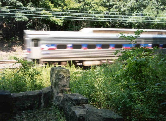
Duffy's Cut
Fifty-seven Irish immigrants died in summer of 1832 at an area known as Duffy’s Cut in Chester County while working on a portion of the Philadelphia and Columbia Railroad, part of the Main Line Works. The workmen were hired by contractor Philip Duffy (1783–1871). Most were young, poor, and recently arrived in the United States on the bark John Stamp. Shortly after work began, a cholera outbreak gripped the area, killing up to a thousand in the Philadelphia region. By the end of August, the entire crew had perished and were buried in an unmarked mass grave.
While their deaths are mostly attributed to the epidemic, archaeological investigations in the twenty-first century showed that several of the men sustained blunt-force trauma to the head and one had been shot at close range. At the time of their deaths, anti-immigrant—and especially anti-Irish—sentiment ran high in the area and sometimes erupted into violence. Cholera was particularly associated with immigration. It has been theorized that this nativist sentiment and fear of the deadly outbreak may have been factors in their violent ends. This photograph taken around 2015 shows the site with a modern SEPTA train traversing the rail line the men were contracted to build. In 2012, their remains were reinterred at West Laurel Hill Cemetery in Bala Cynwyd. Only one man, John Ruddy (d. 1832), was identified; his remains were returned to his family in Ireland in 2013. (Photograph by William E. Watson)
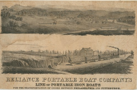
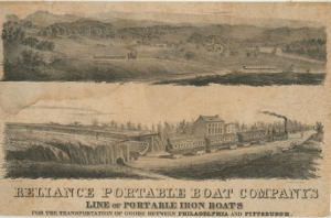
Reliance Portable Boat Company Advertisement ca. 1840
Library Company of Philadelphia
The hybrid Main Line system incorporated railways and canals to traverse Pennsylvania’s varied terrain. This created a market for watercraft that could be transported on rail cars. This illustration from around 1840 advertises iron boats, which separated into sections that could be fitted onto specialty round-bottomed rail cars utilized by the portage railways. In the top image, the assembled boat can be seen plying the canal, while the lower image depicts it disassembled for rail transport. The Reliance Portable Boat Company advertised these specifically to travel the Main Line Works between Philadelphia and Pittsburgh.
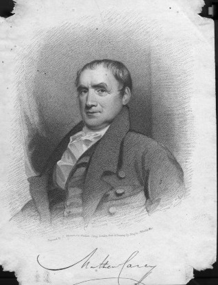
Matthew Carey
The idea of a state-funded canal between Philadelphia and Pittsburgh was aggressively promoted by members of the Philadelphia elite. Matthew Carey (1760–1839), a newspaper editor and political economist shown in this portrait, became one of the most strident proponents of this plan. Carey helped found the Pennsylvania Society for Internal Improvements and solicited donations for research into the latest transportation technology of the era. Architect William Strickland (1788–1854) conducted research in Europe which suggested the new development of railways could be more appropriate, though Carey insisted on a canal and led a vigorous campaign to sway the Internal Improvement Convention and the state legislature in his favor. The state authorized construction in 1826 and construction began on July 4th of that year, the nation’s fiftieth birthday.
Carey was born in Ireland and entered the printing industry. After publishing some inflammatory pamphlets criticizing the Irish penal code and the Parliament, Carey fled to Paris. There, he was hired by Benjamin Franklin (1706–90) to work in his own printing house. Carey immigrated to the United States in 1784 and settled in Philadelphia, where he founded a book printing and selling business. This became one of the largest and most prominent publishing houses in the nation. In addition to America’s first atlas and both the Catholic and King James editions of the Bible, Carey continued to publish political tracts. He variously targeted the general public and government actors to influence national politics and military actions.

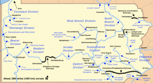
Map of Canals in Pennsylvania
The Main Line of Public Works crossed the state from Philadelphia in the east to Pittsburgh in the west. Beginning at Philadelphia, vessels traveled on the Philadelphia and Columbia Railroad to the Pennsylvania Canal, through a complex series of railways and inclined planes between Hollidaysburg and Johnstown, and finally through the Western Division of the canal. While the system proved expensive and quickly became obsolete with advances in railway technology, it did succeed in shortening the journey between these two cities. By wagon, it took twenty-three days to transport goods and people across the 295-mile span. By the Main Line, it took about four days. Most of the canals fell into disuse in the nineteenth century with only one segment near Harrisburg continuing operation at the turn of the twentieth century.
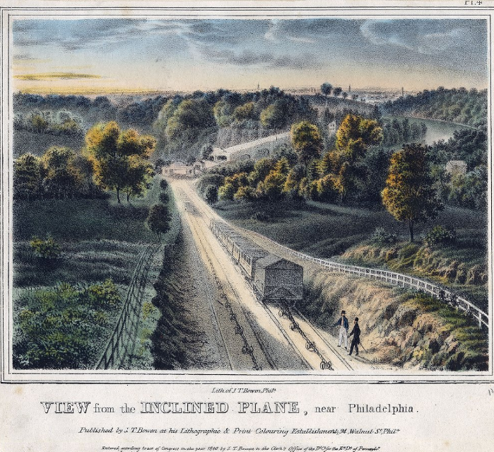
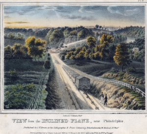
View from the Inclined Plane, Near Philadelphia
Library Company of Philadelphia
Engineers of the Main Line faced a challenge in Pennsylvania’s landscape. In New York, the Mohawk River provided a natural east-west cut across the Appalachian Mountains. Pennsylvania’s rivers proved much less conducive to a straight passage through the Allegheny Mountains which necessitated some stretches of portage. This illustration from around 1840 shows one of these portage segments just west of the Schuylkill River in Philadelphia. A steam engine hauled the cars over 2,800 feet to the top of the Belmont Plateau where they were attached to a steam locomotive and transported along the Philadelphia and Columbia Railroad. At Columbia, another inclined plane hauled the cars down to the Susquehanna River where the first canal segment began.
Railroad technology was still in its infancy in the early 1830s and the Philadelphia and Columbia was one of the first commercial railroads constructed in the United States. Shortly after its completion, railroad technology advanced to create more powerful locomotives capable of hauling the vessels up an incline, rendering the Belmont Plane obsolete. The railway was realigned to follow the Philadelphia and Lancaster Turnpike (now Lancaster Avenue) in 1850, and the plane was abandoned. This rerouted line continues to operate as part of Amtrak’s Keystone Corridor.