Blue Route
Essay
Famous for the many protracted conflicts that delayed its full construction for decades, Pennsylvania’s Mid-County Expressway, also referred to as the Veterans Memorial Highway and, more commonly, the “Blue Route,” is the southernmost section of Interstate 476. The expressway stretches through southern Montgomery and Delaware Counties, linking the Pennsylvania Turnpike interchange at Plymouth Meeting with I-95 north of the city of Chester.
Calls for construction of a north-south expressway through Delaware County, southwest of Philadelphia, first emerged during the late 1920s as a new organization created by municipal reformers, the Regional Planning Federation of the Philadelphia Tri State District, began to work toward a comprehensive plan for the region. Published in 1932, the plan proposed a Delaware County expressway with two route options to alleviate traffic congestion, an outer belt roadway, and a limited access parkway. However, the plans were dropped as the United States became enmeshed in the Great Depression and World War II.
In the immediate postwar years, a large influx of auto-reliant suburbanites further choked Delaware County’s roadways and made it increasingly difficult for manufacturers to efficiently transport goods to and from the Chester area. To remedy these problems, the planning commissions of Delaware and Montgomery Counties submitted a joint application in 1955 for a nineteen-mile expressway, which the Southeastern Pennsylvania Regional Planning Association (a public regional planning agency created by the planning commissions of Bucks, Montgomery, and Delaware Counties) quickly approved. Regional planners viewed the project as a core component of a developing highway network that would ease transportation woes, facilitate commerce, help manage sprawl, and keep the Philadelphia region on par with the nation’s other major metropolitan areas, most of which constructed similar freeway systems during the era.
A Boost from Federal Funds
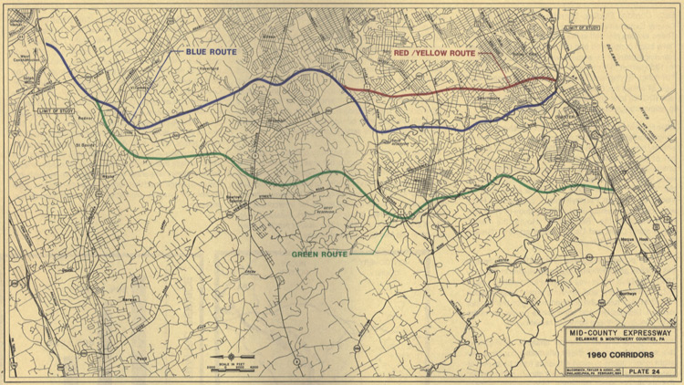
The road’s prospects seemed to increase with passage of the Federal Aid Highway Act of 1956, which promised federal funds for up to ninety percent of its costs. The Highway Act transferred responsibility for the expressway to the Pennsylvania Department of Highways (PDH), which then developed three possible routes, labeled Red, Blue, and Green. The Red Route, later redesignated as the Yellow Route, cut through high-population, predominately working-class communities like Springfield Township in the eastern part of Delaware County. The northern portion of the Blue Route followed the same course but included a separate southern loop that avoided populous areas by cutting westward through the undeveloped Crum Creek Valley and the western edge of Swarthmore College. The Green Route ran farther west than either the Yellow or Blue Routes through mostly undeveloped land.
With most Delaware County residents in favor of a highway but wary of its possible location, the PDH selected the Yellow Route on July 11, 1957, on the grounds that it was the most direct and least expensive course. However, following three months of protests by local residents who feared losing their homes and property tax revenues, the U.S. Department of Public Roads rejected the plan and recommended the PDH move the highway’s path farther west.
Almost three years later, in June 1960, the PDH chose an alternate Blue Route path that bypassed Swarthmore College. Again the announcement drew protests, as this location threatened newly developed parts of Nether Providence Township and appeared to accommodate Swarthmore College at the expense of nearby homeowners. Swarthmore College President Courtney C. Smith (1916-69) downplayed the accusations and refused to endorse the revised route, but many believed it the result of private negotiations between the college and state officials. Lacking public support, the PDH announced an extended delay for selecting a final expressway route.
Fighting the Blue Route
In the intervening years, businesses and residents of Delaware County’s working-class communities supported the alternate Blue Route plan, believing it would aid Chester’s flagging industrial sector. However, many of the county’s middle-class and affluent denizens living near the newly proposed path vehemently opposed it. Recalling some of the earlier criticisms leveled at the Yellow Route, anti-Blue Route protesters claimed the expressway would spur declining property values, rising taxes, increasing crime, and the ruination of the Crum Creek Valley. Angry residents formed civic organizations like the Citizens Council of Delaware County to lead the anti-Blue Route fight and loudly voiced their displeasure at community meetings. Some advocated the PDH revisit the Green Route despite Pennsylvania highway officials’ claims that it was located too far from the county’s population centers to effectively alleviate traffic congestion.
Despite growing opposition, Pennsylvania Governor William Scranton (1917-2013) approved a revised Blue Route plan in May 1963. The plan gained federal approval a month later with four contingencies: that the impact on Swarthmore College be reduced as much as possible, that Swarthmore be aided in acquiring land to offset property lost to the highway, that the highway’s design preserve the area’s natural esthetic, and that portions of the Crum Creek Valley be made available for public use.
Following final federal approval, the PDH broke ground on the Blue Route in 1966, but acquisition delays and conflicts with local municipalities hindered the project from the start. Several ongoing disputes emerged over locations of the interchanges that would control getting traffic on and off the highway. Since the expressway’s initial plans did not include the interchanges, each required separate negotiations and approvals by the state and affected municipalities. By 1970, less than ten percent of the expressway had been built, and its estimated cost had skyrocketed from $30 million in 1956 to $173 million.
Grassroots Activism Elsewhere
Anti-Blue Route activists were not alone in protesting an unwanted expressway during the 1960s and 1970s. Grassroots activists successfully prevented the construction of unwanted roadways in Washington, D.C., San Francisco, New York City, and numerous other cities across the nation. In Philadelphia, anti-highway forces successfully prevented the construction of the proposed Crosstown Expressway, a highway project slated to run parallel to the Vine Street Expressway (I-676) near Lombard Street linking I-95, I-76, and I-676, during the 1970s.
As the freeway revolts dragged on, activists increasingly utilized the National Environmental Policy Act of 1969, which required states to file Environmental Impact Statements (EIS) for all federally funded projects, as a tool for combating construction initiatives they opposed. Anti-Blue Route activists adopted these tactics and quickly secured several court decisions that prevented work on most of the approved expressway route during the early seventies. In 1974, Pennsylvania Transportation Secretary Jacob Kassab (1918-2004) ordered the Pennsylvania Department of Transportation (PennDot) to present an EIS for each section of the Blue Route not already under construction. The decision required additional public hearings and raised the possibility that the project could be abandoned. Delaware County’s “Blue Rooters” as well as those opposing the highway turned out en masse for the meetings and ultimately contributed more than 3,900 pages of testimony to PennDot’s final report.
PennDot submitted the revised Blue Route plan to the Federal Highway Authority (FHWA) in 1978, but a state budget crisis prompted the agency to halt its review a year later. In 1980, U.S. Representative Robert Edgar (1943-2013) established a task force to develop a plan for salvaging the project. The subsequent report called for reducing parts of the highway from six to four lanes, shrinking the size of its interchanges, and tying it to mass transit lines. PennDot adopted the task force’s suggestions, and in 1981 the FHWA approved the project. Not to be dissuaded, several local municipalities and citizens groups then filed two lawsuits on the grounds that PennDot had not adequately investigated less-disruptive routes. The court cases again halted construction and resulted in the completion of a supplemental EIS, which anti-Blue Route activists also contested. Finally, in 1986, the Blue Route’s path to completion was cleared by the Supreme Court of the United States, which upheld a Third U.S. Circuit Court of Appeals’ decision to allow construction to proceed.

The Blue Route fully opened to traffic on December 19, 1991, thereby completing the network of highways surrounding Philadelphia. At a final cost of $750 million, the Blue Route significantly impacted the western part of the Philadelphia metro area, if not fully in the ways its planners intended. Chester’s industrial areas did not experience the economic boost the Blue Route’s supporters anticipated, and the near thirty years of unpredictable delays prevented Philadelphia-area developers from constructing the sorts of large commercial and retail centers that anchor communities and mitigate sprawl. However, the expressway alleviated traffic congestion on Delaware County’s north-south roadways and made it easier for residents to live, work, and shop in the region’s western and southwestern suburbs without entering Philadelphia. Several communities located in close proximity to the Blue Route, including Conshohocken and West Conshohocken near the highway’s intersection with the Schuylkill Expressway (I-76), experienced rapid development and dramatic economic growth during the 1990s and early twenty-first century. With more than 100,000 motorists using the Blue Route each day in the early decades of the twenty-first century, the highway continued to be critical factor in the economic and physical evolution of Philadelphia’s southwestern suburbs.
James J. Wyatt is the Director of Programs and Research at the Robert C. Byrd Center for Congressional History and Education at Shepherd University and President of the Association of Centers for the Study of Congress. He is curator of the forthcoming traveling exhibit “Robert C. Byrd: Senator, Statesman, West Virginian” and co-curator of the collaborative digital exhibit The Great Society Congress, an ACSC project. Wyatt earned a Ph.D. in History at Temple University. He is revising his doctoral dissertation, “Covering Suburbia: Newspapers, Suburbanization, and Social Change in the Postwar Philadelphia Region, 1945-1982,” for publication. (Author information current at time of publication.)
Copyright 2016, Rutgers University
Gallery
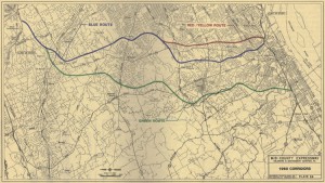
Interstate 476 Blue Route Map
I-476 Improvement Project via Wikimedia Commons
Interstate 476 received its nickname—the Blue Route--from planning maps like this one in 1960 on which Mid-County Expressway planners designated three possible routes for linking Interstate 95 to the south with the Pennsylvania Turnpike to the north in suburban Philadelphia. Each route was designated by a different color on the map. After a long period of debate and controversy over which route was most efficient and would cause the least disruption in the developed suburban area, the Blue Route was selected.
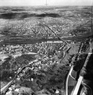
Conshohocken Aerial View
Special Collections Research Center, Temple University Libraries
In 1952 when this photograph was taken, the borough of Conshohocken, Montgomery County, just outside Philadelphia’s far northwest city limit, was a struggling mill town along the Schuylkill River (bisecting this photo in the middle). But Conshohocken’s proximity to the under-construction Schuylkill Expressway (Interstate 76, visible at lower right) and an as-yet unbuilt intersecting highway that came to be known as the Blue Route (Interstate 476, destined to cross the river in the left of this scene), would put the borough in line for immense growth.
The expressways granted motorists speedier access to Philadelphia and Montgomery and Delaware Counties, and the cross-roads convenience led to new offices complexes as well as other business and residential growth.
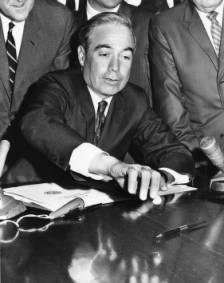
William Scranton
Special Collections Research Center, Temple University Libraries
Highway planners spent years determining the route for Interstate 476, and as with any highway project the planning was influenced by many engineering and political concerns. Area residents and institutions did not want the highway running through their properties, including Swarthmore College in Swarthmore, Delaware County.
Tension developed between William Scranton (shown here) and Swarthmore College’s President Courtney Smith when Scranton allegedly reneged on a campaign promise to ensure the highway would not intrude upon the Swarthmore College campus. This caused delays in selection of the route’s path but after his election as Pennsylvania governor, Scranton did approve a revised plan that skirted the college.
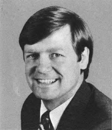
Robert Edgar
Special Collections Research Center, Temple University Libraries
U.S. Representative Robert Edgar's role in the completion of Interstate 476 revolved around assembling a task force that advocated a revised plan for the Blue Route. Eventually, the recommendations of Edgar’s task force were approved by the Federal Highway Authority in 1981.
