Topography
Essay
Landforms and the processes that have shaped them—processes of the Earth, time, climate, and humankind—are key to understanding the configuration and evolution of the greater Philadelphia region. Knowledge about these features derives from topography, the description of landforms which includes, among many others, mountain ranges, hills, valleys, watercourses, and bodies of water.
If there is one adjective to describe the topography of the Delaware Valley, that adjective is gentle. There are neither tall mountains nor deep valleys like those found in northeastern Pennsylvania. The land has always been rich and productive, contributing to the region’s wealth. The Lenape understood its advantages as did successive waves of settlers. The future, however, is never predictable and that same gentle topography characterized by large expanses of tidal areas, may be threatened with inundation if current predictions of relative sea level rise come to pass.
The greater Philadelphia region straddles two physiographic provinces: the Coastal Plain that borders the Atlantic Ocean stretching south from Long Island to the Gulf Coast and Mexico and the Piedmont, a 1,000-mile-long plateau that extends from the Coastal Plain westward to the Appalachian Mountains. The region’s topography includes both the relatively flat landscapes of the Coastal Plain and the rolling ridgetops with steeply incised stream valleys that mark the Piedmont. This transition from the Piedmont to the Coastal Plain explains why the Schuylkill River has cut a steep valley as it flows through the Piedmont from Valley Forge to Fairmount in Philadelphia, while in contrast the topography of Center City Philadelphia and southern New Jersey is relatively flat. Wilmington, founded on Brandywine Creek just upstream from the Delaware River, is similarly located on this transition.
Signs of topography’s central role in shaping the development of the greater Philadelphia area are readily found in historic place names. The Lenape named the location just upstream from the confluence of the Schuylkill River and Wissahickon Creek “Manayunk,” literally the “place where we drink.” There, in the deeply incised Piedmont river valley that the Schuylkill River had cut through some of the oldest rock in North America, the river slowed as it approached the confluence with the Wissahickon Creek, depositing sediment and creating an accessible floodplain where the Lenape could gather, drink water, and fish. Down through the centuries, the power of water has been among the most important influences shaping the metropolitan region.
European settlers lent equally descriptive names to the landscape. In southern New Jersey, the townships on high ground like Mt. Laurel, Mt. Holly, and Pine Hill were named to distinguish them from the surrounding lower-lying terrain of the Inner Coastal Plain. Dutch settlers named the Schuylkill (“hidden river”) for the way the ever-changing mosaic of deposited sediment at its mouth hid the river’s channel. Also named for characteristics of the land, Ridge Pike travels the length of one of the Piedmont’s rolling ridgetops, separating the Schuylkill and Wissahickon valleys. Fair Mount, which became the site of the Philadelphia Museum of Art, looks down on the narrow floodplain of the Schuylkill and Delaware rivers where in 1681, Thomas Holme (1624-95) laid out Philadelphia.
The Coastal Plain Bordering the Atlantic Ocean
Within the Coastal Plain lies approximately two-thirds of New Jersey (including all of southern New Jersey) and all of Delaware south of Wilmington. In Pennsylvania, the Coastal Plain is only a small band, up to five miles wide bordering the Delaware River. The distinguishing topographical feature of the Coastal Plain is its relative flatness, with average slopes of less than one percent and in many places even shallower. Consequently, surface drainage is relatively poor throughout much of the Coastal Plain. Localized flooding is widespread. In some places surface water collects in shallow lakes, particularly in places like the Pine Barrens where most of New Jersey’s cranberry crop is harvested.
The Coastal Plain, however, is not entirely flat. Sporadically along the entire Coastal Plain, places of higher elevation rise 75 to 100 feet above the surrounding landscape. These formations are categorized as “cuestas,” where a cap of consolidated rock sits atop the unconsolidated sands and gravels of the surrounding Coastal Plain, making them more resistant to erosion. In southern New Jersey, these higher elevations form an elongated, northeast-southwest trending, discontinuous belt of higher land. Included in it are Mt. Holly (elevation 154), Mt. Laurel (elevation 148), Pine Hill (elevation 203), and Camden County’s unnamed high point (elevation 219) just east of Berlin. The belt forms a ridgeline dividing the Inner and Outer Coastal Plains. Rivers and creeks on the east side flow across the Outer Coastal Plain and drain to the Atlantic Ocean, while those on its west side flow across the Inner Coastal Plain, draining into the Delaware River.
Topographically, the Delaware River formed the Inner Coastal Plain, where the river has cut a rather broad but shallow valley. At Philadelphia, the valley ranges from six to ten miles wide while at its mouth around Dover, Delaware, it is approximately 40 miles wide. At Philadelphia, the river channel was lined by sandy banks approximately 20’ high into which English settlers at the time of William Penn’s arrival dug caves for protection from the harsh winter.
The Piedmont to the West
West of Philadelphia, the Piedmont’s defining feature is its rolling, gently sloping ridgetops with moderately deep soils dissected by streams and rivers. The Piedmont runs from the New Jersey Palisades along the Hudson River south to Georgia. It varies in width from approximately forty miles in Pennsylvania to 125 miles in North Carolina. Named for the Italian Piedmont, the foothills of the Alps, it is a plateau sandwiched between the lower Atlantic Coastal Plain and the higher elevations of the New England Province and the Ridge and Valley Province that includes the Appalachians, the Blue Ridge Mountains and the Great Smokies.
This geologically complex area has experienced repeated episodes of tectonic plates crashing into each other and then pulling apart over millions of years. Between 500 million years ago until 250 million years ago, the North American and African plates crashed, ultimately forming a high mountain range. During these events, igneous rocks were deformed under great pressure to produce the highly metamorphic schists and gneisses that are found on the Piedmont today. Wissahickon schist, the sparkly, micaceous rock commonly used in buildings in the nineteenth and early twentieth centuries, resulted from these events.
The Schuylkill River originates in the Ridge and Valley province flowing through the Piedmont and onto the Coastal Plain. Flowing south through the soft rock of a limestone valley at Valley Forge, the Schuylkill River encounters a hard ridge of Chickies Quartzite, some of the hardest rock known, where it makes a 90 degree-turn, until it finds a seam or fracture in the ridge and makes another 90 degree-turn, heading southeast. Drivers in this area came to know it through traffic reports as the “Conshohocken Curve.” The water flow then encounters an area of softer, more erodible schists and gneisses around the Manayunk area, through which the river has cut a steep, narrow, 300’ deep canyon.
Water Influenced Regional Economic Development
Given its topography, Manayunk was particularly important to the region’s early industrial development. To facilitate shipping along the Schuylkill River, the Schuylkill Navigation Company built Flat Rock Dam in 1818 upstream from Manayunk, dug a two-mile canal on the wide floodplain, and installed locks along the canal to mitigate the twelve-foot fall from Flat Rock Dam to the river’s downstream path into Philadelphia. To help finance the venture, the company sold access to waterpower that allowed a significant number of mills to be built and subsequently thrive. Past its confluence with Wissahickon Creek, the canyon widens and the river slows as it approaches Fairmount where it drops to the Coastal Plain.

Like Manayunk, many other settlements sprang up at a “fall line,” where a river’s sudden, steep descent produced rapids and water falls that stopped ships from moving farther. Cities formed at such locations because transportation to seaports was easiest from there, and because water power was available to operate mills and factories.
Many of the East Coast’s major cities are located on the fall line between the Piedmont and the Inner Coastal Plain, including Wilmington, Delaware, on Brandywine Creek; Philadelphia on the Schuylkill River; and Trenton, New Jersey, on the Delaware River. As geographer Peirce Lewis (1927-2018) explained, early settlements prospered along the Fall Line as they gained advantage over their competitors by controlling their situation, access to trade routes into the adjacent hinterlands, and the ability to ship goods downstream. These places often became iconic, as illustrated by the gold dome of the New Jersey State Capitol in Trenton sitting upon the higher ground at the Fall Line, and the lofty classical architecture of the Philadelphia Museum of Art atop Fairmount, with its steps made famous by the movie Rocky (1976).
Water Shaped the Land Mass
Below the Fall Line, the rivers and creeks are tidal, and the topography approaches dead flat. As the rivers and creeks fall from the Piedmont to the Inner Coastal Plain, they deposit sediment as their velocities slow, and they spread out over the plain, separating into multiple channels called distributaries. Twice a day, tides flow up the Delaware River from Delaware Bay and back out again. The river has no perceptible gradient or slope throughout its tidal reach from Trenton to Delaware Bay, and because of this the course of the Delaware River has remained relatively stable.
Sediment deposited when the river overfloods its banks has been the main source of land building on its floodplain for the last 6,000 years. In Philadelphia the Schuylkill River – the Delaware River’s largest tributary – has flowed into it, depositing its sediment and forming a large delta that covered most of the land south of Snyder Avenue in South Philadelphia as well as the land upon which the stadiums, the Naval Yard, the former Sunoco Refinery, and the Philadelphia International Airport were built.
The sediment formed large areas of tidal freshwater wetlands, which were neither land nor water but instead an “aqueous terrain” that was constantly shifting. These areas were some of the first to be modified by European settlers who diked and drained them for agriculture. In the eighteenth and nineteenth centuries, they were thought to harbor miasmas, unhealthy airs and vapors that caused yellow fever, resulting in their draining, filling, and use for urban expansion. In an ironic twist, draining these wetlands did reduce yellow fever, not because they produced vapors, but because they provided habitat for the Aedes aegypti, the mosquito that transmitted the disease. Tidal freshwater wetlands subsequently came to be recognized to be some of the most productive landscapes on the planet. Of the approximately 6,000-10,000 acres (some measurements estimate the top end of the range was as high as 12,800 acres) that once covered the Schuylkill River delta area, only approximately 280 acres remain.
Environmental Threats to the Region
In the Delaware Valley region, the most severe impacts from climate destabilization and sea level rise can be expected in the filled tidal wetland areas. Because the Mid-Atlantic coastline is subsiding while mean sea level is rising, relative sea level rise in the region is estimated to be twice the global average.
Much of the region’s vital infrastructure has been built in the Schuylkill River delta area. Because of the importance to the region’s economy, along the Delaware riverfront in both Pennsylvania and New Jersey, the impacts of sea level rise in the early twenty-first century created potential for widespread reverberations. Relative sea level rise, coupled with storms of increasing frequency and severity, created increasing risk of severe flooding for areas within the tidal zone. Critical infrastructure such as the Philadelphia International Airport, the innovation and technology hub of the Philadelphia Naval Yard, and the Southwest Sewage Treatment Plant that processes sanitary and storm sewage from Philadelphia, Montgomery, and Delaware Counties, confronted needs to adapt or be relocated. Transportation infrastructure such as the I-95 corridor and Admiral Wilson Boulevard also faced future reconstruction or relocation. Entire neighborhoods built over filled tidal wetlands such as Tinicum Township and Eastwick, the largest urban renewal project in the country, were projected to be partially inundated within thirty years and completely inundated by the end of the twenty-first century. The salt line – that is, the extent to which saltwater reaches upriver – was projected to move farther toward Philadelphia, potentially imperiling the intakes for Philadelphia’s drinking water supply.
Low-lying tidal areas have always been attractive to build upon because less labor has always been required to build dikes and drainage canals in their transformation from tidal freshwater wetlands to agricultural lands than it did on the Piedmont to cut down large, mature trees in the transformation of forested to agricultural lands. As technology advanced, these lowland areas became even more attractive for development and the land modifications more extensive. Yet, these same areas proved to be most vulnerable as climate changes and sea levels rose. Planners in the 2020s proposed that these areas be redesigned to make room for the river, mimicking their original drainage patterns to help alleviate flooding caused by anticipated sea level rise. On the other hand, higher elevations in the Piedmont likely faced far fewer challenges from many of these same issues.
Michael Nairn is a landscape architect and faculty member of the Urban Studies Program at the University of Pennsylvania. The author is deeply indebted to the late Ian McHarg who taught generations of landscape architectural students to read the landscape of any place they might find themselves by analyzing physiography and topography. (Author information current at time of publication.)
Copyright 2023, Rutgers University.
Gallery
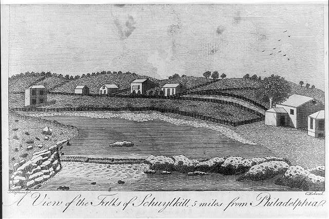
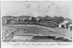
Fall Line at the Schuylkill River (East Falls)
The Falls of the Schuykill, depicted in this 1793 etching, were formed by the meeting of the Piedmont and Coastal Plain. This meeting, forming a “fall line,” bisects the Schuykill River several miles upriver from the Fairmount Dam. A fall line creates rapids and waterfalls as the elevated, hard rock of the Piedmont and flat, sandy sediment of the Coastal Plain collide. After the Fairmount Dam’s construction in 1822 raised water levels, only a few protruding rocks from the falls remained visible.
Eighteenth- and early nineteenth-century accounts describe the falls, which spanned two-thirds the width of the Schuylkill River. At normal to high water levels “water flowed over it and made a beautiful cascade” that dropped “five or six feet,” creating rough waters that ran “with great rapidity and much noise” that could sometimes be “heard at a distance of from one to five miles.” At low water levels the falls formed “a complete natural dam.” Many travelers took note of the “picturesque” scenery and locals enjoyed lounging and fishing there. By the mid-eighteenth century, many wealthy individuals established country estates in view of the Falls. In the early nineteenth century, tourism flourished.
Navigating rivers crossed by fall lines is often difficult. Only after the Fairmount Dam was built were boats able to pass from either direction the natural barrier of rocks formed by the fall line. Rough waters produced by fall lines also frustrate river crossings. The Falls Bridge (built 1894-95) passes above the former falls. It is the first of more than five bridges constructed over the fall line to not collapse due to rough waters, overloading, or fire.

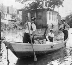
Flooding in Eastwick
Special Collections Research Center, Temple University Libraries
Most of Eastwick, a neighborhood in Southwest Philadelphia, is susceptible to flooding since the neighborhood was built atop a portion of the Tinicum Marsh. This August 1933 photograph pictures Red Cross workers en route to an Eastwick school used as an emergency shelter for residents.
Much of the marsh wetlands were drained and filled in the 1950s and 1960s to allow the development of Eastwick. In addition to Eastwick, once considered the largest urban renewal area in the country, other projects (e.g., Philadelphia International Airport) have reduced 5,700 acres of wetlands in 1900 to just 200 acres by 1960. The John Heinz National Wildlife Refuge conserves the remaining land, in addition to 1,200 acres granted by Congress in 1972, and the diverse wildlife that inhabits it.
Eastwick’s flood susceptibility derives from its marshy foundations, which is exacerbated by its proximity to the Darby-Cobbs Watershed and the Delaware and Schuykill rivers. Climate change serves further risks. Rises in sea level and more severe hurricanes, for example, cause great risk to low-lying areas like Eastwick. Even more, floods of increased frequency and severity threaten the release and spread of toxic waste through groundwater flow. In 1999, after waters receded in the aftermath of Hurricane Floyd, “landfill leachate,” according to one 2017 study, was found in the basements of many homes located near one of the town’s “two Superfund-designed former landfills.”
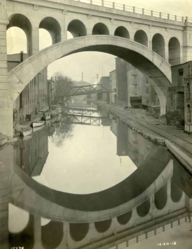
Manayunk Canal
Special Collections Research Center, Temple University Libraries
The name Manayunk translates to “the place where we drink,” which refers to the floodplain on which Manayunk sits at the junction of the Schuylkill River and Wissahickon Creek. The Lenape people congregated there to fish and drink water. Later, nineteenth-century developers utilized Manayunk’s topography for their benefit. The Manayunk Canal, for example, pictured here in a 1918 photograph by William Nicholson Jennings, was constructed to prompt economic growth in the region.
Constructed between 1815 and 1828, the canal was once part of a 108-mile navigation system built by the Schuylkill Navigation Company. The system linked coal-rich regions north of Reading, Pennsylvania to Philadelphia’s ports along the Delaware River. This scheme led to the construction of numerous factories and mills in Manayunk, some of which used the canal to aid their operations. The canal in part helped Manayunk become a prominent industrial town by the mid-nineteenth century and earn the nickname “Manchester of America.”
The canal ceased operations in the 1940s and is no longer connected to the Schuylkill River. In 2023, the Philadelphia Water Department’s Flat Rock Dam Betterment project called for revitalizing the canal by stabilizing and preserving its historic features, improving its water quality, and rejuvenating the Schuylkill River Trail.
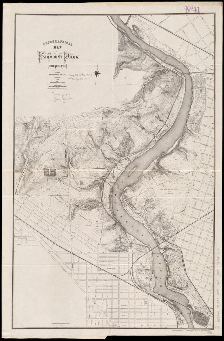
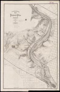
Topographical Map of Fairmount Park
This 1870 topographical map portrays ground elevations and depressions within Fairmount Park and in surroundings areas.
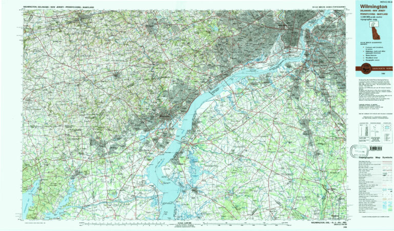
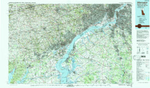
Topographical Map of the Greater Philadelphia Area
This 1984 topographical map portrays various topographical features within the Greater Philadelphia Area, such as ground elevations, woodland and swamped areas, as well as manmade works like railroads and airports.
Backgrounders
Connecting Headlines with History
- A 1,400-foot levee could be built in Eastwick. Here’s what you need to know (WHYY, September 14, 2023)
- A levee could be built in flood-prone Eastwick. Delaware County has concerns (WHYY, November 14, 2023)
- Portion of Schuylkill River Trail near Manayunk to close Monday for restoration project (WHYY, September 9, 2023)