Schuylkill River
Essay
Extending some 130 miles in a generally southeasterly direction from its source at Tuscarora Springs in the anthracite coal region of Schuylkill County to its point of confluence with the Delaware River in Philadelphia, the Schuylkill River has played a central role in shaping the character and aspirations of Philadelphia and the regional hinterland through which it flows. The river’s watershed of about two thousand square miles lies entirely within the state of Pennsylvania. Its upper portions originate in the alternating ridge-and-valley formations of the Appalachian Mountains. While historically a prime source of sustenance in its fish and fresh water, the river, as it drew industry to its banks, found its natural benefits diminished by pollution and waste products. In the latter part of the twentieth century, new generations of environmentally conscious citizens acted to restore its natural qualities with multiple benefits for improved health and recreation for the three million people living within its watershed.
Native inhabitants had been camping and fishing on the banks of the Schuylkill for as much as fourteen thousand years before the first Europeans arrived in the seventeenth century. The area was first settled by the Unalachtigo subtribe of the Lenape or “original people” who settled in bands along the rivers and creeks of southeastern Pennsylvania. They referred to the river as Ganshowahanna, meaning “Falling Water” or Manayunk, which meant “where we drink.” A navigator, Arendt Corrsen (?-1645) of the Dutch West India Company, gave the river its modern name in 1628, when he became the first European to navigate it. Translated as “hidden river,” the name is thought to refer to the location of its mouth, obscured from the Delaware River by League Island, later the site of the Philadelphia Naval Shipyard. In 1633, Corrsen was appointed commissary and instructed by the company to acquire land on the river for a plantation and trading post. He purchased a tract known as “Armenveruis” from the Lenape, and in the same year, the Dutch erected Fort Beversre[e]de on the site. This fortification stood until about 1651 near the confluence of the Schuylkill and Delaware Rivers near where the Platt Bridge was later erected.
Even as European settlement proliferated, the Lenape maintained settlements along the river, including Nittabakonck (“place which is easy to get to”), a village located where the Schuylkill meets the Delaware River. It was this area where William Penn (1644-1718) chose to lay out Philadelphia. Granted a charter to settle the area from Charles II (1630-85) of England as partial repayment of a debt, Penn nonetheless chose to buy the area from the Lenape to ensure peace for the colony. Selected with an eye to tapping the rich agricultural hinterland to assure the city’s growth, the site relied on its rivers for supplies of food and lumber that could be floated to the city when water was high enough—usually the spring.
Many streams flowed into the Schuylkill, including the Wissahickon, Plymouth, Sandy Run, Skippack, Pennypack, and Perkiomen Creeks, prompting the construction of dams and mills to produce grain, lumber, oil, paper, and powder and enhance trade. The presence of natural rapids, however, presented obstacles to boats. After several failed attempts in the 1780s and 1790s to fund improvements that would make the rapid-filled Schuylkill navigable, Philadelphia businessmen finally convinced the Pennsylvania legislature in 1815 to approve the charter of the Schuylkill Navigation Company to construct a slack water navigation system of canals, dams, and pools between Philadelphia and Pottsville to the northwest in Schuylkill County. Despite setbacks in funding and the death of the chief engineer, the system opened to navigation in 1824, and with an extension to Port Carbon four years later it generated the shipment of newly discovered riches of anthracite coal. Although supporters of the new system envisioned it primarily as a means of securing the flow of natural products to Philadelphia, especially grain (which local businessmen feared might otherwise be sent to Baltimore by way of the Susquehanna River), coal quickly dominated the business.
Industry Expands Along the River

By the 1840s, the transport of coal had shifted to rail, further enhancing development throughout the Schuylkill River valley. The shift could be seen in Reading, the county seat of Berks County. Boosted not just by the Schuylkill Canal but also the completion in 1828 of the east-west Union Canal connecting the Schuylkill and Susquehanna Rivers, the town of Reading continued to grow following incorporation of the Reading and Philadelphia Railroad in 1833. Farther south, Phoenixville, located at the junction of the Schuylkill and French Creek, utilized the Chester County Canal, completed in 1828, and the Reading Railroad to gain easier access to raw materials and more efficient transportation of finished products from iron works that had their origin at the onset of the nineteenth century. More generally, from 1820 to the 1860s iron works, foundries, manufacturing mills, blast furnaces, rolling mills, railroads, warehouses, and train stations sprang up throughout the Schuylkill Valley. Tiny farm villages grew into vibrant company towns, then transitioned into small cities as major industry and supporting businesses transformed local economics and populations swelled. By 1857 more than a million tons of freight moved each year through the valley’s diversified transportation system.
Within Philadelphia County industry concentrated along the river’s east bank. The effect of shifting energy regimes could be seen most notably in Manayunk—originally called Flat Rock Bridge—where by 1828 there were as many as ten textile mills powered by water backed up by a dam at the Schuylkill and directed through a two-mile canal constructed by the Schuylkill Navigation Company. The introduction of industrial capitalism undercut the dominance of flour milling as it had flourished for almost a century along the nearby Wissahickon Creek and prompted such popular designations of Manayunk as the “Lowell of Pennsylvania” and the “Manchester of America.”
Even in the early years of Philadelphia’s commercial growth, officials grew concerned about assuring pure water for its residents. In 1799, the city established a watering committee and selected the Schuylkill as the city’s primary water source. As the city quickly outgrew a pumping station located in Centre Square at the heart of the old city, it directed city engineer Frederick Graff (1775-1847) to supervise construction of a water works at Fairmount, the prominent hill located on the Schuylkill’s east bank just north of the original city boundary. There engines would pump water from the river to a reservoir at the top of the hill, where it was distributed by a system of pipes to city subscribers. When steam engines proved costly and dangerous to operate, the watering committee converted the system to waterpower, assisted by construction of a dam at the Falls of the Schuylkill. Located where the river descends from the elevation of the Pennsylvania Piedmont to the low-lying Atlantic Coastal Plain, the area had long been the most famous natural attraction in the vicinity of Philadelphia. Not surprisingly, the area attracted the interest of Philadelphia’s wealthiest residents, who built country retreats free of the crowds, heat, and disease associated with the city. Construction of the dam at that location created a quiet pool upstream, ideal for rowing and skating. For the villas on the east bank of the river, however, the change brought swamp conditions and flooded meadowlands that reduced the attractiveness of country living. As conditions worsened, the city, in a further effort to protect the purity of the water, began buying up those estates, turning their properties into parkland. Boosted by state legislation in the 1860s, Philadelphia’ expansive Fairmount Park took form on both sides of the Schuylkill in the following years.

Dredging Near Girard Point
Most of the commercial traffic on the Schuylkill River plied the portion between Center City and its mouth because navigation farther north was impeded by the dam at the falls. Following the Civil War a series of wharves and docks went up on the river west of Center City to accommodate ships and barges transporting cargo including coal, ice, lumber, and stone. This increased commercial traffic prompted the United States Army Corps of Engineers to plan river improvements near the Schuylkill’s mouth. In 1875 and 1876 dredging took place in the channel near Girard Point, adjacent to what became known as the Penrose Ferry Bridge and near Gibson’s Point. This portion of the river was used to ship over 10.8 million bushels of grain to foreign ports.
The Pennsylvania Railroad recognized the economic advantages of Philadelphia’s wharves for the import and export of grains including wheat, oats, and corn. Among the elevators constructed to sustain this trade, the largest was the International Navigation Company of Philadelphia’s 650,000-bushel Girard Point elevator erected in 1874 near the junction of the Schuylkill and the Delaware Rivers. Other industrial facilities taking advantage of a Schuylkill River location included the Atlantic Refining Company, established at the end of Passyunk Avenue in Point Breeze in 1860. It marked the advent of an influx of petroleum refineries into South Philadelphia. Initially established as a storage facility, by the 1880s it had become one of the largest refineries in the United States.
The transformation of land on both sides of the Schuylkill River from rural estates and farms to industrial and intensive-level residential use had direct consequences for the health of the river. As the Philadelphia region grew and its industries expanded, the Schuylkill’s pollution increased. The headwaters contributed the effluent from mine drainage and coal silt, and the lower sections were plagued with the waste of a large and growing population. According to the city engineer’s report for 1866, “Below Manayunk, the river assumes a dark, dirty, milky appearance, and is covered with soiled waste and shreds from shoddy mills … There is no doubt that a constant deterioration in quality is going on, which, if not arrested, will ultimately force the city to abandon the Schuylkill as a source of supply, if the time to do so has not already arrived.”
Problems worsened in the early twentieth century. As anthracite coal production peaked, large amounts of coal washing wastewater and coal silt discharged into nearby streams. To this were added sewer deposits described in a study by the Philadelphia Bureau of Engineers in 1913 as polluting the entire length through the city, to the point of preventing development along its banks either for pleasure or business. By 1927 the Army Corps of Engineers estimated that the Schuylkill River and its tributaries contained thirty-eight million tons of coal waste.
Clean Streams Act of 1937
Civic leader John Frederick Lewis (1860-1932) captured the sense of dismay shared by many residents in a 1924 illustrated address presented at the Historical Society of Pennsylvania published the same year. “Scores of cities with but a fraction of Philadelphia population, a tithe of her wealth, and a vastly larger per capita debt,” he charged, “might be cited as having recognized the wisdom of waterfront reclamation {and} sewage disposal by other means than by fouling their most valuable asset. Why should Philadelphia not do likewise?” The situation began to change when the Pennsylvania legislature unanimously passed the Clean Streams Act in 1937. A decade later Governor James H. Duff (1883-1969) directed a massive cleanup effort resulting in the excavation of twenty-three impounding basins along the river to receive dredged silt. In 1978 the Pennsylvania legislature responded to appeals from the Schuylkill River Greenway Association founded four years earlier, by designating the Schuylkill the state’s first Scenic River.
Restoration of the river accelerated at the turn of the twenty-first century. Building on the state’s designation of the Schuylkill as a Scenic River, advocates along the river corridor succeeded in 2000 in securing formation of the Schuylkill Greenways National Heritage Area and associated Greenways River Trail along the 128-mile corridor of the Schuylkill Valley with a commitment to repair environmental damage to the river and its surroundings. A 2003 report to the Schuylkill River Development Corporation on the state of the Schuylkill watershed brought together twenty-five nonprofit organizations with state and local agencies to pledge cooperation in addressing needs for clean water impacted by both population gains and losses along the Schuylkill’s tributaries. As a signature project, the organization launched Schuylkill Banks Park, a strip of parkland along the east bank of the river extending from the foot of Fairmount below the waterworks and south into the central city with an eventual destination of the Delaware River. Other organizations devoted to environmental stewardship of the river included the Delaware Riverkeepers Network, the Schuylkill River Greenway Association, the Schuylkill Highlands Conservation Landscape Initiative, the Middle Schuylkill River Conservation Landscape Initiative, the Lower Schuylkill River Conservation Landscape Initiative, the Schuylkill Action Network, the Phoenixville Iron Canal and Trails Association, and the Headwaters Association.
As much as was accomplished to boost the Schuylkill as a recreational asset, its industrial character, and the hazards it represented, were manifest in 2019 when a devastating explosion erupted at the former Atlantic Refinery site. While government and civic leaders sought to secure new environmentally safe uses for the property as the company entered bankruptcy, the costs of remediation and repurposing land under private ownership remained an obstacle, even as nearby residents struggled to secure compensation for damage to their health.
Over many years river area residents sought balance between beauty and production, serenity and empire. A longtime source of recreation, the Schuylkill’s mixed legacy was well captured by artist Thomas Eakins (1844-1916). A rower himself, Eakins captured the serene presence of rowers on the river never distant, however, from the emblems of industry located nearby. The modern effort to balance industry with nature was the reclamation of tidewater gardens at Southwest Philadelphia’s Schuylkill border. There, at the oldest surviving botanical garden in North America, Bartram’s Garden, founded in 1728 by botanist John Bartram (1699-1777), modern programs introduced area residents to the natural features of the river and the importance of their conservation. With industrial activity never far away from this spot, it served in the twenty-first century as a prime vantage point for encountering the river’s mixed heritage. Coincidentally the City Parks Association revisited John Frederick Lewis’s Redemption of the Lower Schuylkill with a similarly-named exhibit. Clearly, conservationists still had work to do. Yet even after centuries of development along the river’s banks, forests regrew to cover about 41 percent of the basin, representing important areas for recreation and wildlife. Agriculture still occupied 40 percent of the acreage while developed lands represented about 13 percent. Surface and groundwater resources in the basin continued to provide drinking water for more than three million people.

Howard Gillette is Professor Emeritus of History at Rutgers-Camden and Co-editor of The Encyclopedia of Greater Philadelphia. This essay incorporates information gathered and compiled by Douglas McVarish, Principal, West Jersey Historical Research. (Author information current at time of publication.)
Copyright 2022, Rutgers University.
Gallery
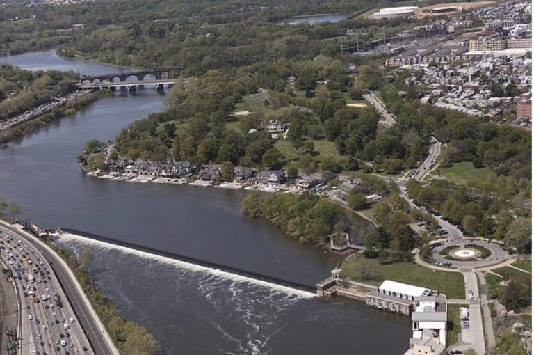
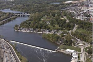
An aerial view of Philadelphia and the boathouses along the Schuylkill River
Completed in 1822, the Fairmount Dam runs across the Schuylkill River north of Fairmount Water Works. Called "Schuylkill Pond,” the man-made lake that resulted from the damming of the river in the early nineteenth century made the section of the river seen in this photograph perfect for ice skating and rowing. Rowing clubs soon sprang up along the east bank of the Schuylkill River. Named Boathouse Row, the Victorian era boathouses west of the Philadelphia Museum of Art comprise rowing teams from area universities, social rowing clubs, and one public rowhouse. Kelly Drive, named after the famed Philadelphia rower John B. Kelly Jr. (1927-85), runs alongside it.
The boathouses are considered the center of the rowing community in the United States. The Schuylkill River became the setting for several major annual regattas, including the Head of the Schuylkill. (Photograph by Carol M. Highsmith)
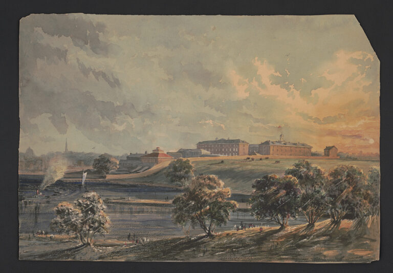
Schuylkill Arsenal, ca. 1850
The chromolithographic process pioneered in the early nineteenth century finally allowed lithographers to make multi-color prints using oil-based inks. Although time-consuming to make, chromolithographs became popular in children’s’ books, trade labels, and advertisements throughout the Victorian era. This color lithograph of the Schuylkill Arsenal artfully blends a number of colors to show the sun’s waning light, the shadows of the trees, and the few people who are gathered on both sides of the river. The well-known and prolific Philadelphia chromolithographer James Fuller Queen (1820 or 1821-86) created such specialized prints throughout his long career.
Queen’s eye for detail and ease producing prints across multiple genres garnered a large audience for his chromolithographs. By the Civil War era, Queen’s chromolithographs of activities and places associated with the war—hospitals, soldiers, and armories—were popular pieces in fundraising efforts for the Union cause. Queen’s enlistment in the Pennsylvania Militia in 1862 did not stop him from producing chromolithographs and continued to influence his work.
First built in 1800, the Schuylkill Arsenal shown in this view made by Queen between 1850 and 1860 was a staging ground for the 1804 Lewis and Clark Expedition, and it provided supplies for the U.S. military, later specializing in textiles. During the Civil War, the Arsenal hired 10,000 seamstresses and tailors to provide the Union Army with uniforms, tents, blankets, and bedding. While the buildings were demolished in 1963, the remaining original wall was added to the National Register of Historical Places.
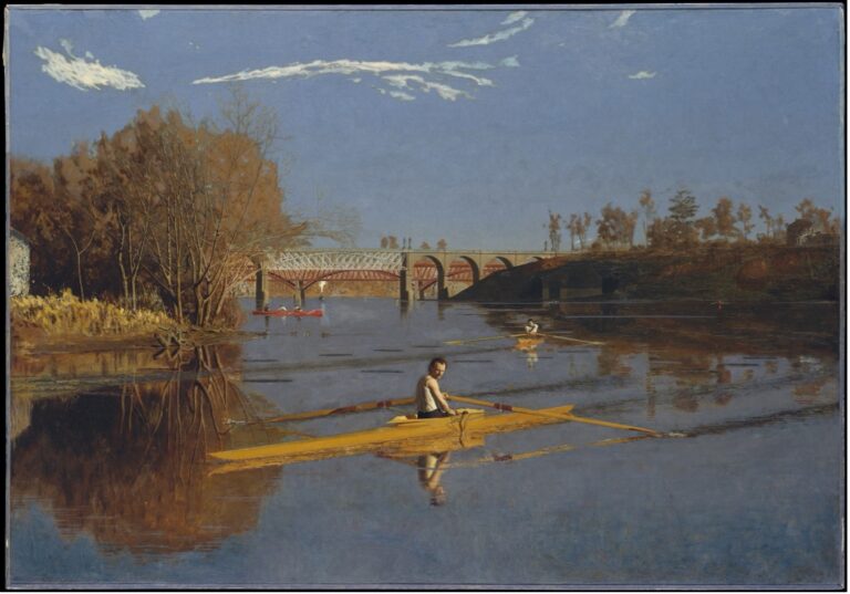
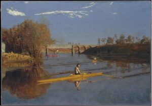
The Champion Single Sculls (Max Schmitt in a Single Scull) (1871)
The rower in the foreground of this 1871 painting by Thomas Eakins (1844-1916) is believed to be Max Schmitt (1843-1900), a contemporaneous well-known amateur rower. Eakins was himself an avid rower, and in this painting he painted himself at the oars of the scull in the middle distance. “Eakins” is inscribed on the front of the boat. In the background is a rail bridge, where a faint trace of rising smoke indicates the presence of a train set to cross.
One of the most important American realist painters, Eakins used his hometown of Philadelphia as the frequent subject the hundreds of paintings he created in his decades-long professional career. Its inhabitants and landscapes feature heavily in his paintings and later photographic work.

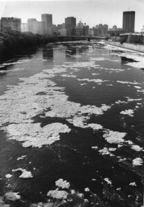
Polluted foam coats the Schuylkill River (1981)
Special Collections Research Center, Temple University Libraries
Due to the Schuylkill River’s long history of mixed uses, contaminated water was well documented even in the eighteenth century. During the twentieth century, city government, Philadelphia residents, and business owners became increasingly alarmed over the state of the river. Compounded industrial and sewage waste and continued pollution jeopardized economic development as the sights and smells of the river discouraged new building projects. Beginning in the 1940s, Pennsylvania Governor James H. Duff (1883-1969) ordered a massive cleanup, beginning with dredging to remove millions of tons of often foul-smelling silt accumulation. However, obvious examples of pollution and waste, like the kind seen in this 1981 photograph, continued to mar the Schuylkill River into the late twentieth century.
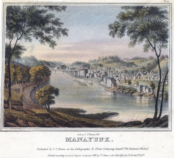
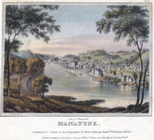
Manayunk ca. 1838
Library Company of Philadelphia
The area of eastern Pennsylvania is home to indigenous people who refer to themselves as the Lenape (“original people”). The Lenape who camped and fished along the Schuylkill River called the body of water Manayiung (“place where we drink”). Before the arrival of the Europeans in the seventeenth century, Lenape groups inhabited an area encompassing later New York, New Jersey, and Delaware.
The town of Manayunk, located along a hilly bend in the Schuylkill north of the center of Philadelphia, boomed with the construction of the dam, locks, and canal by the Schuylkill Navigation Company in 1818. By the mid-1830s, the two cotton mills seen in this lithograph dominated the town’s riverfront. Weaver turned manufacturer Joseph Ripka (1789-1864) commissioned the large mills, and at one time they employed over 300 people.
In 1854, the town of Manayunk was incorporated into the city of Philadelphia.

Cherry Blossoms Along the Schuylkill
The Schuylkill River became an example of environmental revitalization after more than two centuries of substantial industrial use. By the mid twentieth century, the river was notoriously polluted. Concerted local activism and political and economic investment by the state of Pennsylvania spurred significant ecological rehabilitation. The state designated the Schuylkill River a Scenic River in 1982, the first in the state. In the early 2000s, the Schuylkill River Development Corporation helped create the Schuylkill Banks River Project, an eight-mile river walk along the east side of the river below the Fairmount Dam. (Photograph by Rob Rabena)
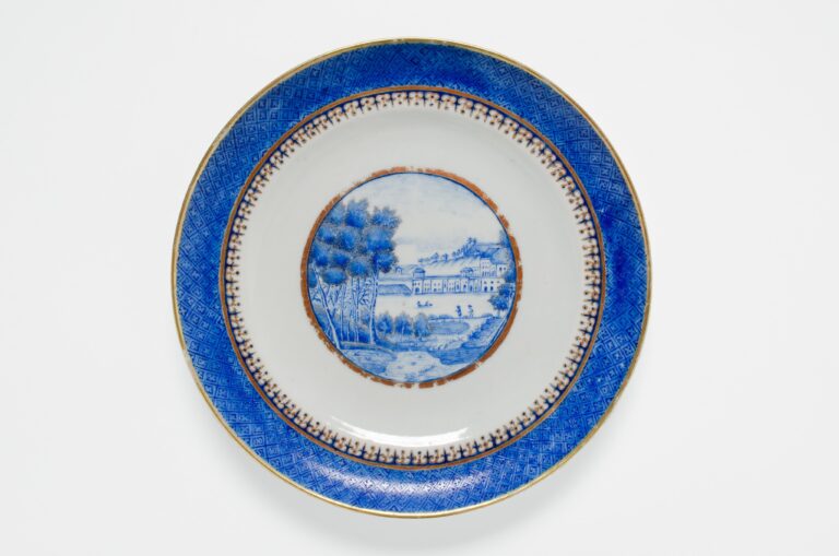
China Plate showing the Philadelphia Waterworks ca. 1820s
As the most populous American city for much of the eighteenth century, Philadelphia was internationally recognized as a major center of trade, arts, and culture. With its continued commercial growth, Philadelphia’s city leadership began to look for cleaner and more efficient ways to provide water to its booming population.
Following a series of devastating yellow fever epidemics, city leaders formed a Watering Committee in 1799. Constructed between 1812-15, the Fairmount Water Works became an international tourist destination. The first municipal water system in the United States, it was renowned as a scientific and architectural marvel. The building’s Classical Revival exterior alongside the natural beauty of the river impressed numerous visitors, including Charles Dickens, who first visited in 1842. Images of the Water Works appeared in lithographs, paintings, plates, and other art objects, like the blue and white china plate seen here. The plate was crafted in China during the 1820s by an unknown artist.

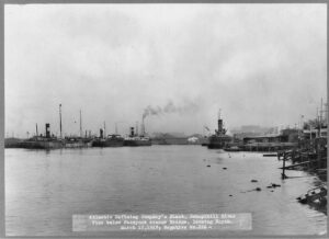
Atlantic Refining Company's plant, Schuylkill River, view below Passyunk Avenue Bridge, looking North
When this photograph was taken in 1917, this area of the Schuylkill River had experienced a decades-long boom in industrial development. The increased commercial usage of the river spurred a number of projects launched by the U.S. Army Corps of Engineers in the years after the Civil War. These projects included dredging the river to remove silt build-up that impeded the movement of an increased number of ships. Within twenty years of creation, the Atlantic Refining Company became one of the largest refineries in the United States. Its arrival in 1860 heralded the establishment in South Philadelphia of the petroleum industry, which increased its presence in the twentieth century.
Throughout the nineteenth century, the transformation of land on both sides of the Schuylkill River from rural estates and farms to industrial use had direct consequences for the health of the Schuylkill River. As the Philadelphia region grew and its industries expanded, the Schuylkill’s pollution increased. Sewer deposits polluted the entire length of the river by 1913. As anthracite coal production peaked, the U.S. Army Corps of Engineers estimated in 1927 that 38 million tons of coal wastewater flooded the Schuylkill River.
A devastating explosion rocked the site in 2019, reminding the city of the continually dangerous aspects of industrial legacy.