Urban Renewal
Essay
Urban renewal was a nationwide program aimed at maintaining the dominant position of central cities in the face of the urban crisis and suburban growth that marked the decades following World War II. Philadelphia was a leader in this revitalization practice, reserving more federal urban renewal grant funding ($209 million), by the end of 1965, than anywhere else in the country besides New York City. The city also stood out for its distinctive “Philadelphia Approach,” which operated at a smaller scale and in a less physically destructive manner than that of the typical American city. Yet, just as across the country, urban renewal in Philadelphia yielded mixed results that incited controversy.
Federal legislation critically enabled the public-private partnerships behind urban renewal’s implementation, while local actors tailored these policies’ effects in practice. Title I of the Housing Act of 1949 provided loans and two-thirds federal grants to support the acquisition of land and clearance of the areas designated as blighted. Private developers would then redevelop these properties. They did so initially for new housing. Following passage of the Housing Act of 1954, however, they pursued other reuses as well, including shopping, industry, and offices. The Housing Act of 1954 also expanded federal funding to support housing rehabilitation in addition to site clearance.
Philadelphia’s Central Urban Renewal Area (CURA) Study, of 1956, shifted the city towards rehabilitation by focusing timely investments of limited funding on “conservable”—rather than “worst-first”—areas of the city. Even so, the national program—epitomized by Robert Moses (1888-1981) in New York City—emphasized top-down approaches to renewal that generally prioritized demolition of buildings and displacement of population in order to make way for new, modern development. Advocates of the program hoped, variously, to replace dilapidated housing, modernize the city and its relationship to automobiles and highways, strengthen the urban tax base by upgrading the uses of central city land, and create appealing alternatives to the suburbs in order to stem the flight of industry, commerce, and middle- and upper-class residents.
Like hundreds of cities across the country, Philadelphia actively embraced urban renewal. By 1952, it had designated sixteen redevelopment areas, most of them centrally located. Over time, these numbers only increased. In the mixed success of its big downtown office and commercial developments, as well as its creation of many large housing projects, Philadelphia’s experience was quite representative of the national story. But, under the leadership of Edmund Bacon (1910-2005), executive director of the Planning Commission, and William Rafsky (1919-2001), who as the city’s housing director and development director (among other roles) was the driving force behind the CURA policy, Philadelphia also distinguished itself in several ways. It relied more heavily on alternatives to wholesale clearance, “curing slums with penicillin, not surgery,” as Architectural Forum famously put it. The result was a pedestrian-oriented approach to urban renewal that also valued neighborhood conservation. Housing was a particular priority in Philadelphia, and the city built upon its row house past to emphasize low-rise development, not just high-rise construction—for multiple income levels. Finally, the city responded directly to deindustrialization both by rehabilitating existing facilities and by planning for new industrial parks in less central urban locations. Thus, the Philadelphia Approach to urban renewal was both typical and distinctive.
Early Urban Renewal
Philadelphia’s urban renewal era began even before passage of the key federal acts. Following Pennsylvania’s 1945 enabling law, the city established its redevelopment authority in 1946. The Better Philadelphia Exhibition of 1947, held at Gimbels department store, deployed photographs, maps, movies, a diorama, a life-size model of a rehabilitated row house, and a vast 14-by-40 foot scale model to showcase Edmund Bacon and architect Oskar Stonorov’s (1905-1970) vision for the city. The reform movement used the exhibition as a key tool for promoting their planning-oriented vision for the city. The event set the stage for the 1951 victory of Mayor Joseph S. Clark, Jr. (1901-1990) who, followed by Mayor Richardson Dilworth (1898-1974), supplied political leadership behind urban renewal. In tandem, the 1948 formation of the Greater Philadelphia Movement, a civic group of key business leaders, provided private sector support for urban renewal in the city.
Philadelphia’s first urban renewal project was in East Poplar, a neighborhood located in lower North Philadelphia. As in most early renewal projects, planners selected East Poplar due to its significant levels of blight. In eradicating that blight, the city also attempted to provide housing affordable to displaced residents. Although the city supplemented Title I funds to reduce rents in the Towne Center development, not everyone could afford those rates. New slums formed around the perimeter to house lower-income displacees. A venture between the Philadelphia Redevelopment Authority and American Friends’ Service Committee turned to cooperative rehabilitation, but again yielded rents too high for many of the original residents. The problem of displacement and housing affordability would persist throughout the era of urban renewal.
The more visible Penn Center project was the city’s first major downtown redevelopment endeavor. It began in 1952, when the Pennsylvania Railroad vacated its Broad Street station and the adjacent blocks of elevated tracks. This expanse of infrastructure, known as the “Chinese Wall,” had divided this central city location and left dilapidated conditions along its periphery. Bacon hoped to see the large site developed as a single entity that could knit the area back together and serve as a welcoming civic and commercial center. He supported a design by architect Vincent Kling (1916-2003) modeled on New York City’s Rockefeller Center. A street-level pedestrian mall, with parking garages at its ends, would connect three new elevated office towers and offer sweeping sight lines to City Hall. Below ground, a pedestrian concourse would include stores, restaurants, a skating rink, an open central plaza, and connections to rail. Yet the city lacked the funds necessary to purchase the privately owned site and control the design. Instead, the railroad company selected private developers who pared down the original concept for cost-saving purposes, yielding a built project that fell short of its grand urban design expectations.
Market East
Market East was another major downtown project. There, planners sought to realize the commercial redevelopment that was largely unmet at Penn Center. In 1958, the Planning Commission introduced a proposal for a complex of buildings, multimodal transportation access, open-air pedestrian circulation, and office space above that competed with the scale of suburban shopping. Architects Bower & Fradley designed the enclosed, climate-controlled mall. The combined efforts of the Redevelopment Authority, the national retail developer Rouse Company, and the Southeastern Pennsylvania Transportation Authority (SEPTA) led to the opening of The Gallery at Market East in 1977. It included two anchor stores, 122 shops and restaurants, a parking garage, and approval for a new commuter rail tunnel to connect with existing transportation lines. Gallery II, a companion project located one block east, opened in 1983. It included another anchor store, smaller-scale shops, an underground rail station, and office space. Although the malls were originally aimed at drawing suburban shoppers back downtown, it was urban patrons who largely fueled their impressive early sales levels.
While Penn Center and Market East aimed to revitalize downtown commerce, other projects strove to eliminate commercial uses from residential areas. The renewal of Washington Square East into the Society Hill residential area embodied this approach. There, large-scale clearance of a wholesale food market gave way to three new high-rise towers by I. M. Pei (b. 1917). More unusual, however, was the combination of smaller-scale spot demolition, modern infill construction, and historic preservation that characterized the row houses west and south of the towers. Under the guidance of Society Hill resident and National Park Service architect Charles Peterson (1906-2004), historic preservation selectively restored the neighborhood’s Georgian and Federal past. At the same time, it also eradicated the encroachments of most late nineteenth- and twentieth-century architecture, mixed-use and multifamily properties, and industrial facilities. Bacon also inserted park space and greenways to provide brick- and tree-lined pedestrian routes traversing the neighborhood. The adjacent Penn’s Landing project, along the waterfront, revitalized park and cultural spaces aimed at tourists. Most of Society Hill’s previous residents—including largely Eastern European and African American renters—were replaced with more affluent owners who were able to afford the costs of single-family home rehabilitation. Although heralded for its embrace of preservation, the project also offered an early example of gentrification.
Not all housing projects focused on the upper class. In the sixteen thousand sparsely populated acres of the Far Northeast, Bacon aimed to apply suburban-style neighborhood planning principles to an urban setting. The proposal included superblocks with clustered housing, open space, and pedestrian pathways. Surrounding these superblocks, looped streets responded to the topography, while arterial streets and mass transportation offered more distant connections on the periphery. This model would counter both developers’ interest in building more familiar row houses and existing community members’ preferences for suburban-style tract housing. By contrast with typical redevelopment, the city did not own this land, and much of it was unbuilt. Thus, the Planning Commission’s main role was to develop subdivision plans to guide future development. The realized results were mixed. Early projects lacked walkable shopping and mass transit connections, yielding auto-centric living after all. Yet, many of the streams endured, and the clustered row houses made the units affordable to working- and middle-class residents.
Building in part upon the CURA Study’s responsiveness to deindustrialization, the Far Northeast also became a destination for new industrial development that might otherwise have departed the city. In the postwar era, many longtime downtown industries were either being displaced by urban renewal or highways, or were just forsaking their multilevel buildings in search of suburban-style, single-story facilities. Between 1959 and 1970, the Philadelphia Industrial Development Corporation (PIDC) financed over one hundred transactions involving moves to or expansion of industrial parks. In this way, the PIDC facilitated industrial decentralization, but still within city boundaries. Still, the majority of its support funded the renovation of existing buildings in the inner city. Although this included declining minority neighborhoods, most of the employment opportunities went to white workers. In other parts of the city, such as West Philadelphia’s University City Science Center, more service-oriented industries like education and medicine also benefited from urban renewal partnerships.
Big Plans for Eastwick
Industrial development also clustered in Eastwick, a three-thousand-acre neighborhood in southwestern Philadelphia. The vast majority of the housing across all of Eastwick was in good repair, with the northwestern portion of the area—consisting mainly of rowhouses occupied by roughly one-third of Eastwick’s population—being particularly well-planned and -maintained. The neighborhood’s southern section, however, was less densely built and lacked necessary public infrastructure, including sewers and sufficiently paved roads. This was a particular challenge given the marshy nature of this landscape. The urban renewal plan for a “city-within-a-city” aimed to make Eastwick the largest redevelopment project in the country by merging housing and industry. Planners targeted twenty thousand jobs and homes for up to sixty thousand people in racially integrated development. While these goals were not fully met, the project did yield many blue-collar jobs and lower middle-income housing units. But these accomplishments came at the cost of the preexisting integrated community, which had unsuccessfully protested against the project from the outset.
Citizen opposition at Eastwick was not atypical. By the 1960s and 1970s, urban renewal projects were inciting increasing protest across the country. Critics charged that the program was synonymous with “Negro removal,” given that African Americans and other minority residents were the disproportionate victims of displacement. Federal legislation required the relocation of previous residents into safe and sanitary homes, and Title II of the Housing Act of 1949 included provisions for additional public housing construction. But, even improved physical environments could not make up for the psychosocial consequences—or “root shock”—that accompanied the breakup of close communities. Not all residents were eligible for public housing, but those who found accommodations there often suffered the relatively rapid decline of many of these new projects. For example, even Louis Kahn’s (1901-74) thoughtfully designed Mill Creek project, consisting of towers amidst a landscaped park in West Philadelphia, ultimately ended in demolition. Further opposition to urban renewal—from Jane Jacobs (1916-2006) among others—decried its destruction of still-vital neighborhoods and solid buildings, the vague definitions of slums and blight, and the failure of the program to realize many of its intended economic gains.
Postwar freeway development, funded through the Interstate Defense and Highway Act of 1956, often linked in with urban renewal projects and caused similar kinds of displacement. The massive destruction of these highways incited protests that sometimes stopped the bulldozer in its tracks. For example, the prolonged efforts of a diverse coalition halted the Crosstown Expressway that would have eradicated a significant African American neighborhood and commercial corridor while dividing Center City from South Philadelphia.
Whereas urban renewal was characterized by top-down efforts focused on physical design, the countermovements that developed in response advocated for bottom-up, community-led approaches aimed at social and economic revitalization. New federal urban renewal grants ceased with the Housing and Community Development Act of 1974, which supported Community Development Block Grants with more diverse, local applications instead. But the legacies of postwar urban renewal continued to endure. They survived through the contemporary remaking of unsuccessful renewal projects, the preservation of other built projects as they reached the fiftieth anniversary mark, and ideally the application of lessons learned to the attempted revitalization of twenty-first-century cities.
Francesca Russello Ammon is Assistant Professor of City and Regional Planning and Historic Preservation at the University of Pennsylvania. Her research focuses on the history and culture of the built environment. She is the author of Bulldozer: Demolition and Clearance of the Postwar Landscape (Yale University Press, 2016). (Author information current at time of publication.)
Note: This essay was edited in February 2020. The name of the architecture firm responsible for the Gallery was corrected to Bower & Fradley, and the description of Eastwick was edited to reflect the state of the neighborhood prior to demolition.
Copyright 2016, Rutgers University
Gallery

Planning Exhibit, Better Philadelphia Exhibition
City of Philadelphia, Department of Records, City Archives: City Planning Commission Records
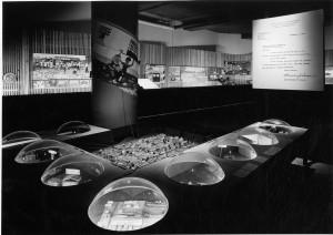
The Better Philadelphia Exhibition, which ran from September 8 to October 15, 1947, at Gimbels department store in Center City, showcased new ideas for revitalizing Philadelphia after decades of depression and war. Along with sculpture, light shows, information about the urban planning profession, a life-size model of a rehabilitated row house, and a history of the city’s growth, an elaborate diorama of Philadelphia served as the centerpiece of the exhibition. Spotlights focused on specific areas of the city, and portions of the diorama then mechanically flipped over to reveal their imagined future. Although urban planner Edmund Bacon often receives credit for the exhibit’s design, it was modernist architect Oskar Stonorov who first conceived the idea and recruited Bacon’s help. Stonorov’s business partner, the famed architect Louis I. Kahn, also contributed to the exhibition’s design as did Philadelphia City Planning Commission (PCPC) members Robert Leonard and Robert B. Mitchell.
Better Philadelphia’s creators hoped to stir citizens’ imaginations while overcoming public objections to urban planning. In an effort to enlist public support for their vision, planners presented their concepts in accessible terms, as indicated by the exhibition theme, “What City Planning Means to You and Your Children.” Taking cues from architect Daniel H. Burnham, whose 1909 Chicago plan was distributed to schoolchildren, Bacon and Stonorov visited elementary schools prior to the opening and asked students to draw their own plans for the future city; the drawings were later displayed at the exhibition. Following the event, the Philadelphia City Planning Commission asked the 365,000 visitors their opinion about the exhibit’s proposals; nearly 65 percent responded that they would pay higher city taxes to see the envisioned features come to fruition.

Three Key Planners
Special Collections Research Center, Temple University Libraries
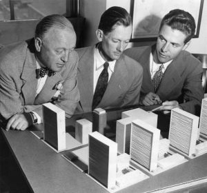
The Penn Center project was Philadelphia’s first major downtown redevelopment endeavor. It began in 1952, when the Pennsylvania Railroad vacated its Broad Street station and the adjacent blocks of elevated tracks. This expanse of infrastructure, known as the “Chinese Wall,” had divided this central city location and left dilapidated conditions along its periphery. Urban planner Edmund Bacon (center) hoped to see the large site developed as a single entity that could knit the area back together and serve as a welcoming civic and commercial center. He supported a design by architect Vincent Kling, at right in this photograph.
Kling’s design was modeled on New York City’s Rockefeller Center. A street-level pedestrian mall, with parking garages at its ends, would connect three new elevated office towers and offer sweeping sight lines to City Hall. Below ground, a pedestrian concourse would include stores, restaurants, a skating rink, an open central plaza, and connections to rail. Yet the city lacked the funds necessary to purchase the privately owned site and control the design. Instead, the railroad company selected private developers who pared down the original concept for cost-saving purposes, yielding a built project that fell short of its grand urban design expectations.

New Society Hill Construction
Special Collections Research Center, Temple University Libraries
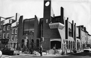
Society Hill is one of Philadelphia’s oldest neighborhoods, with more buildings surviving from the eighteenth and nineteenth centuries than any other in the country. Usually defined by the boundaries of Walnut, Lombard, Front and Eighth Streets, this area south of Independence National Historic Park evolved over the centuries as a diverse, complex residential and commercial neighborhood. Although deteriorated by the 1950s, it was reborn as a city historic district and attracted international attention for its innovative combination of urban renewal and preservation.
The plan to revitalize the area was spearheaded by city planner Edmund Bacon and National Park Service architect Charles Peterson. Peterson oversaw the selective preservation of the neighborhood’s Georgian and Federal past. New organizations such as the Philadelphia Historical Commission and the Old Philadelphia Development Corporation were created to certify historic houses and acquire property and then resell it to owners who agreed to follow strict preservation guidelines. At the same time, Bacon insisted on incorporating greenways and new construction in modernist style, such as the high-rise Society Hill Towers and Hopkinson House, to create a neighborhood distinctly different from a collection of historic buildings.
While restrictions created by the Old Philadelphia Development Corporation prevented new homeowners in Society Hill from drastically altering their historic homes, regulations for new construction were more lenient. New buildings could reflect modern architectural styles and the owner's tastes, as long as the designs were approved by the Philadelphia Redevelopment Authority.
This house on the corner of Second and Lombard Streets used building materials typically used in adjacent row houses, such as brick and concrete, but applied a modernist design to give the building its distinctive look. This image from 1973 shows the house while the interior was still under construction. This building became a commercial property in the 1980s and later a drugstore for Society Hill residents.

Cramer Hill Protest Sign, Camden (2004)
Like so many cities facing the loss of industry and residents in the years following World War II, Camden, New Jersey, embraced the prospect of generous federal funding to advance urban renewal. An early champion for such redevelopment in the city was Alfred Pierce, who won a significant victory as mayor in 1959 running on an independent ticket under the banner “Save Our City.” Pierce envisioned wide scale clearance of abandoned or antiquated structures, especially on the downtown waterfront, to make way for new office, retail, and entertainment facilities. Such bold plans brought with them the demolition of significant numbers of inner city housing units and the displacement of large numbers of their African American residents. Such actions at a time of rising Black militancy naturally provoked protest, and ultimately many of Pearce’s most ambitious projects were blocked in court.
Some forty years later, with the financially desperate city of Camden under unprecedented state supervision, Melvin “Randy” Primas, who became Camden’s first Black mayor after his election in 1981, acting for the state as its appointed chief operating officer in the city, initiated another round of redevelopment. This time the prime target was the working-class Cramer Hill neighborhood nestled between the Delaware and Cooper Rivers. Selected for massive redevelopment, involving both the relocation of current residents and an influx of outsiders drawn to newly constructed homes located near a golf course developed on what had been a long-abandoned landfill, the project once again provoked a furor.
Targeting the Cherokee Development Company that had been selected to develop the golf course and nearby marina, area residents spoke out overwhelmingly against the project. Only when the courts again struck down the plan did state and city officials abandon the project. The prime area selected for golf was subsequently redeveloped more closely in line with resident needs in mind with construction of the Salvation Army’s Kroc Center, a major recreation facility serving both the neighborhood and the region. (Photograph by Howard Gillette for The Encyclopedia of Greater Philadelphia)
Children Outside of Southwark Plaza
Special Collections Research Center, Temple University Libraries
Buoyed by the success of Society Hill, other Philadelphia neighborhoods began to experience revitalization during the 1970s. Southwark, located just south of Society Hill, was transformed into a middle-class district by the efforts of individual homesteaders and, later, real estate developers. Even though it was not subject to the physical destruction seen in Society Hill, this neighborhood experienced a similar degree of social disruption. In a few short years, Southwark saw a dramatic decline in its working-class population along with the conversion of its mixed-use streetscapes into expensive residential-only corridors.
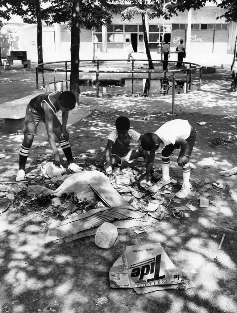
To assist working-class residents near Southwark who could not afford the increased costs of living in the newly gentrified neighborhood, the Philadelphia Housing Authority in the late 1960s built three apartment buildings, named the Southwark Plaza, along Washington Avenue between Third and Fifth Streets. The apartments were inexpensive for residents but they only provided basic housing and residents complained that the Housing Authority was not responsive to maintenance issues. As the nearby blocks of Queen Village saw large investments from city organizations to restore houses and raise property values, Southwark Plaza apartment buildings had broken elevators, limited electricity, and a trash-filled landscape. Some residents burned trash inside their apartments for heat, or left it inside broken elevator shafts or outside the apartment buildings. In this image from 1977, three children are looking through trash at one of Southwark Plaza's dilapidated playgrounds.

University City Science Center
Special Collections Research Center, Temple University Libraries
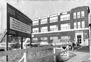
The University City Science Center became one of America's first urban research development parks when it was incorporated as a nonprofit entity in 1963. Developed through a joint venture by the Philadelphia Industrial Development Corporation and the West Philadelphia Corporation, the Science Center has a dual mission to promote the scientific, medical, and engineering fields that could be commercialized, and to develop real estate that would attract others to Philadelphia to specialize in the sciences. This photograph from 1969 shows the first Science Center building, on the corner of Thirty-Fourth and Market Streets, as the plans for future construction were underway. The sign in this image advertised the $100 million Science Center project that would eventually consist of a fifteen-building complex surrounding Market Street (between Thirty-Fourth and Thirty-Eighth Streets). The Science Center has been directly responsible for helping more than three hundred science- and engineering-based companies develop in the Philadelphia region, while also bringing in new land development in the West Philadelphia area. However, construction of the additional buildings required the demolition of nearby residential areas, including more than 400 homes rented or owned by working-class families.

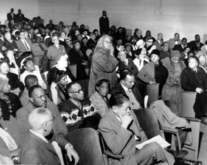
Community Meeting with the Redevelopment Authority, 1965
Special Collections Research Center, Temple University Libraries
The construction of the University City Science Center displaced residents of the Black Bottom, a predominantly African American neighborhood. The Black Bottom was located in the Market Street corridor between the campus of the University of Pennsylvania and the Powelton Village and Mantua neighborhoods of West Philadelphia. The Redevelopment Authority held meetings with the community, such as this one in 1965 at the Drew School, in advance of the demolitions. However, despite community opposition, the Black Bottom blocks were razed and the displaced residents were relocated in a haphazard way to other parts of West Philadelphia.
Protests against the displacements came not only from Black Bottom residents but also from students. In 1969, student demonstrators from Penn and other Delaware Valley colleges and universities staged a sit-in at Penn’s College Hall. One of the demonstrators’ primary aims was to force the Science Center to build high-quality, low-income housing units on its property. The students won that demand, although fifteen years would pass before low-income housing would be built; the units were located in the block bounded by Market, Chestnut, Thirty-Ninth, and Fortieth Streets on land the Science Center reverted to the city for public housing.
Since 1984 and continuing into the twenty-first century, the former residents of the Black Bottom and their families convened annually for a picnic in remembrance of the neighborhood. The picnic, held in Fairmount Park, was made official in 1999, when the Philadelphia City Council recognized the second Sunday in August as Black Bottom Day.
Crosstown Community Office, 820 South Street
Special Collections Research Center, Temple University Libraries
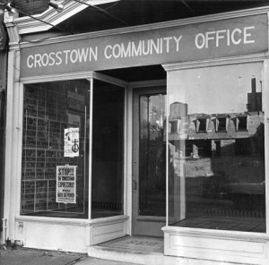
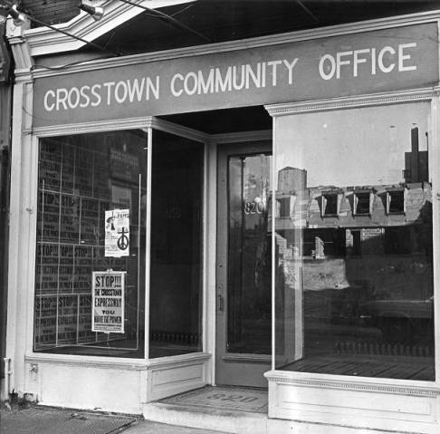
Postwar freeway development, funded through the Interstate Defense and Highway Act of 1956, often linked in with urban renewal projects and caused similar kinds of displacement. For example, when the Crosstown Expressway was initially proposed, either South Street or Washington Avenue was going to face major redevelopment in order to accommodate the new highway. Though Washington Avenue had fewer residential homes, the possible damage to the rail line and historic buildings disqualified it from consideration. Instead, areas of South Street were marked as “blighted” and in need of redevelopment. Many places on and around South Street were bustling African American business and social centers, and the proposed entrance to the highway at Broad and South would have required the closing of the Royal Theater, the most popular and prominent venue for arts and culture in Philadelphia’s African American community.
In response to the proposed highway, residents of the neighborhoods surrounding South Street banded together to stop destruction of their community. Calling themselves the “Crosstown Community,” they rented office space, such as the storefront here at 820 South Street in December 1970. A row of homes in need of repair is visible in the reflection, because though the expressway was never built, the threat of its construction changed the neighborhood forever as many residents moved to find a better living situation.

Backgrounders
Connecting Headlines with History
- Edmund Bacon, architect of modern Philadelphia, and champion of skateboarders (WHYY, May 22, 2013)
- Franklin Square Park celebrates decadelong resurgence (WHYY, March29, 2016)
- In Philadelphia, a discussion about urban renewal and the 'trauma' of eminent domain (WHYY, April 8, 2016)
- Revitalization stirs up memories of a time Sharswood pulsed with all that jazz (WHYY, August 30, 2016)
- A 1940s documentary about housing and poverty in Philadelphia, and progress since then (WHYY, December 20, 2016)
- The Gallery: Past, Present, and Future (WHYY, October 23, 2018)
Links
- Edmund N. Bacon’s Pitch for Center City’s Revival: Form, Design and The City (PhillyHistory Blog)
- Urban Renewal: The Remaking of Society Hill (Philadelphia: The Great Experiment vis YouTube)
- Ed Bacon, In Perspective (Hidden City Philadelphia)
- Philadelphia City Planning Commisssion
- Nearly 60 years later, city starts over in Eastwick (Philly.com, August 16, 2016)
- Renewing Inequality: Urban Renewal, Family Displacements, and Race, 1955-66 (University of Richmond Digital Scholarship Lab)